
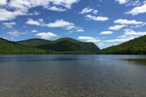
It happened beside a pretty, conifer-fringed pond. A white boulder overlooked the pond’s rippling waters, which blurrily reflected cotton-wool clouds and blue sky. I climbed onto the boulder to take a photograph and knew as soon as I had done so that I was done with this hike, that I’d reached the point when a trek becomes sheer, joyless endurance.
There was nothing wrong with the pond. I was, for sure, tired after 11 miles of backpacking in the day’s sticky heat. But what really killed the hike for me on that rock was that I realized that, finally, the black flies and mosquitoes had won. No matter how beautiful my surroundings, the bugs’ dancing before my eyes, their whine and their touch, put everything beyond enjoyment.
 The problem was I couldn’t be done with this hike. I was in Baxter State Park in northern Maine, surrounded by a wilderness half the size of Fairfield County. This outing would not be over until tomorrow, not until I had spent a night in the woods and retraced all my steps.
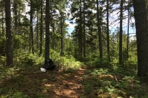
My night — spent on the banks of the Wassataquoik Stream — was comfortable enough once I’d zipped myself inside the mesh of my tent. In the morning, very early, I waded two streams and set off north, toward the comfort of my car. Soon after 6 a.m. there were thunder and downpours. Misery upon misery you might think. But the rain brought cool temperatures and suppressed the insects. I’d set myself the task of reaching Pogy Pond by 9:00 and hiked along cheerfully singing “Pogy by nine, Pogy by nine” to the Addams Family theme. I reached the pond’s rain-spattered waters at 8:30.
My backpack to the Wassataquoik Stream formed the middle part of five days of mid-June hiking in Baxter. It was a low-level trek, mostly hemmed in by forest. But from the banks of ponds there were views to Baxter’s many peaks, and it was in the mountains that I spent the other days of my stay, experiencing highs that outweighed by a mile my lowland woes.
I spent my first Baxter nights at South Branch Pond Campground in the Park’s less visited north. On the first evening, sitting on the campground dock — a place of reduced bug harassment — I looked over Lower South Branch Pond to the cliffs of Center Ridge and pondered the exertions of the hike I had planned for tomorrow. I drew encouragement from two hikers from Quebec who had just finished what I was pondering. “No bugs up there,” they said.
 The Traveler loop is an 11-mile trek over three 3,000-foot-plus summits — Center Ridge, The Traveler, and North Traveler. The trails are rough and lonely, the views enormous. The young Quebeckers completed the loop in seven hours, they said; it took me closer to nine, with ample summit-loafing time. In retrospect, I have realized that The Traveler loop is an exceptional hike, standing out in a field where the competition is abundant and stiff. Here are three reasons for its Great Hike status: Climbing onto bare and bouldery Center Ridge to views Katahdin — Baxter’s emblematic peak and Maine’s highest, snow-flecked in June — 12 miles south across uninhabited wilds; dipping briefly into shade and fragrance in a ridgeline forest of undersized fir and birch; descending oh-so-steeply from North Traveler Mountain to close the loop and cool off in Lower South Branch Pond.
For those in vehicles, Baxter is connected by the Park Tote Road, 40-some miles of dirt track. I had hoped to drive the Tote Road south for my final mountain hike, but the need for post-winter repair had kept it closed just down from South Branch Pond. I drove instead on roads outside the Park and arrived after 82 miles at Baxter’s southern entrance, barely 20 miles as the crow would have flown from my starting point.
 Baxter’s southern end has Katahdin, and the 5,268-foot massif dominates the area in every sense. The campground at South Branch Pond had been almost empty, but that at Katahdin Stream was filled with hikers planning to tackle the mountain in the morning. I wasn’t sure if I’d be joining them. I’d climbed Katahdin 12 years before, although seeing nothing from its socked-in summit. It would be nice to reach the top on a sunny day, and that was the forecast.
My campsite was right at the Katahdin trailhead, and even before I rose in the morning, I heard a steady procession of dawn hikers heading for the mountain. By breakfast, I still had not decided between Katahdin and another peak called The Owl. Starting up the trail that led to both, I was favoring The Owl but then impulsively thought “Katahdin!” But when I reached the trail register and saw the long list of entries for Katahdin and just one for The Owl, I changed my mind again. The Owl, wise choice.
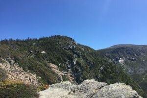
The Owl was a wooded climb, a bare-rock scramble, and finally an easy stroll to its 3,670-foot summit. The summit commanded stunning views of Katahdin — cliffs, ravines, saddles, all in the sharp focus of a brilliant day. I climbed onto the summit boulders and knew that I’d reached the point when a trek becomes sheer, joyous delight.
Rob McWilliams, a local resident, is the author of The Kiss of Sweet Scottish Rain: A Walk from Cape Wrath to the Solway Firth. Taking a Hike appears eight times a year. Contact Rob at “McWilliams Takes a Hike” blog and Facebook. He’d love to hear from you.